Idaho: Mt. Borah (12,668 feet)
Date: August 6, 2016
Distance: 8 miles round trip via Chicken Out Ridge
Elevation: 12,668 feet
Vertical gain: 5,285 feet
Bathrooms: 2 vault toilets near the trailhead
Time: 12 hours 44 minutes

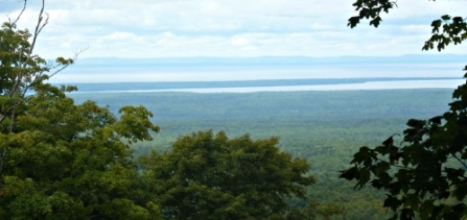
View from the Summit
“Who gets us into these crazy adventures?” I joked as we clung to the side of a rock face on a one inch ledge. A fall, if we survived, would be ugly at best. Navigating the narrow ledges with sometimes questionable handholds and a drop-off that I never looked down to fully evaluate was scarier for me than jumping from a plane. Mt. Borah (officially named Borah Peak) is a serious endeavor, but worth the effort.
Advance Intel
The night before the climb, we had dinner at the Bear Bottom Inn in Mackay (pronounced MACK-ee, not Muh-KAY), along with several locals. The people in Mackay are some of the nicest I have ever met. Hopefully, when you’re there you’ll have the same good fortune of sharing a beer with Terry and his friends. Those who had climbed Borah were happy to offer the advice of sturdy footwear, hiking poles, and a good supply of water. We left the restaurant to high fives from the locals and Cheers to Borah.
Prior to arriving in Idaho, I consulted other highpointers who had climbed the mountain. They all used similar words to describe the experience – steep, hard, relentless, punishing. I wish I could offer more encouragement to future climbers, but these words are all accurate.
In fact, one of the most helpful descriptions in my research came from an article in the Idaho Press-Tribune.
Take a staircase with nearly 10,000 stairs, make half of the steps loose, cover the other half with loose dirt and gravel, take out the handrailing, narrow some of the steps to a couple inches wide, and have sections of the staircase cling to the side of a 2,000-foot cliff, and you’ll have Mount Borah.” – Randy Lavorante, Idaho Press-Tribune
How can you pass up a mountain this awesome? With this description in hand, I somehow recruited my friend, Anna, who had made an attempt on Mt. Hood with me in 2013. She recruited her marathon-runner friend, Meredith. Together with Shaun, the four of us got up before 4 am to journey to the trailhead of a mountain that promised to deliver an adventure.
Going Up
The mountain starts off just fine, relative to the entire experience. The trail near the bottom is surprisingly soft on the knees, at least on the way up. The unrelenting steepness starts about 15 minutes in.
A few hours and 3,700 feet of elevation gain later, we had made it to the beginning of Chicken Out Ridge. It was at this point that the obvious trail completely disappeared and sheer rock face emerged. No blazes are painted on the rocks; you are left to your own devices to figure out the best path without plummeting to your death. Had we been without guides, we surely would have scratched our heads wondering where the trail went and how to proceed. In fact, a group behind us (oddly enough, also from the DC area) asked befuddled, “Is that the trail?” I’m a thrill seeker with a willingness to take risks. But, if we’d been unguided, all four of us absolutely would have turned around with one glance at Chicken Out Ridge. No question.

Shaun approaching COR

Meredith and Shaun coming up the first leg of Chicken Out Ridge – before we clung to the mountain
At Chicken Out Ridge, we got into our harnesses and roped up. Across narrow ledges, searching for handholds and footholds, we traversed our way across the rock face in teams of two. In a few places, we climbed down to later go up with a total of about 500 feet of elevation gain on COR. After the famous 20 foot downclimb on the way to the summit, which we borderline rappelled, we had officially cleared what I considered to be the scariest and most dangerous part of the mountain.

Down climbing the 20 foot wall to complete Chicken Out Ridge on the way up

The snow bridge immediately following COR was wide and easily passable without any concern. A week prior, a man had slid 300 feet off of the snow bridge and required a helicopter rescue.
After dropping our technical gear and refueling with a quick snack, we pushed on for the final leg of the climb – a “hike” that feels as though it’s straight up. Thankfully, our guides prepared us mentally for the full range of emotions we were about to experience. After COR, it looks like you can almost touch the summit. We were pumped thinking this was in the bag. But, with constant loose scree, an intensely punishing uphill, and a summit that seemed to keep moving farther away, even the toughest of us mentally began to question our ability to close this thing out.
The guides warned that we’d reach a point where we would think it wasn’t possible and then all of a sudden, we’d find ourselves on the summit. It sounds a little silly, but that’s exactly what happened. Maybe 50 vertical feet from the summit, it seemed I’d never get there. No tears flowed, but I felt like I wanted to cry. I’d invested so much time and money – not to mention energy – to get to this point and I didn’t think I had enough gas in the tank to get there. But, I didn’t come this far to be inches from the summit. I wanted it. Badly.
Like the guides said would happen, all of a sudden, I was standing on the summit. It’s kind of like Disney World where the Magic Kingdom appears farther away on the approach than it actually is. You reach a point where the steep terrain ends and it becomes a relatively easy stroll along the top ridge to the summit.
At the Summit
Our time at the summit was not the sit, enjoy a sandwich, and take in the expansive views experience I’d come to envision. No, we’d entered into an electrical storm. White Dippin’ Dots, called graupel, were falling from the sky. The summit buzzed loudly with electricity, vibration coursing through us. Cell phones started to go haywire. A brewing storm was one mile away, with lightening threatening to strike. Hikers were shouting to “get off the mountain!” and fleeing in a mass drove.
Safety be damned, I wasn’t leaving without a few pictures. I was disappointed to discover that the iconic blue Borah flag had been stored improperly at some point in recent history and is no longer there. In its place is a scrap of a white sheet, shown in our picture. It got the job done, but it wasn’t the beautiful blue flag I’d wanted to pose with.

The new white Mt. Borah flag (too windy to hold it alone, so our Boise teammate helped)
After getting the victory shot with the flag and a few vantage point photos, I needed to sign the register to complete the accomplishment. The register notebook had long since been emptied of free space. The ammo box was stuffed full with random scraps of paper people brought up to add their name to the list.
At this point, one of our guides arrived in a full sprint to the summit with Anna in tow, shouting that it was critical to get off the summit. I would be permitted one quick photo with Anna and we had to get down immediately. We snapped the photo. Then, against my guide’s advice, I took a second to sign the register vertically in the margin shared with climbers from 2015 – the only iota of space available, grabbed my pack, and began the descent. I was the last one to leave the summit that day.

Summit from another angle
A note for future climbers – you will have space to sign your name to the accomplishment. Two days after my climb, my guide emptied out the old notebooks and shreds of paper (which he mailed to the Highpointers Foundation for demographic analysis), and replaced it with a clean one. The Highpointers Foundation also has plans to replace the ammo box which is not closing properly.
The Trip Down
Most people appear to take longer on the descent than on the ascent. Not us with that storm rolling in. It took a little over 7 hours to reach the summit and 5.5 to descend. The guides moved us down the loose scree and through COR in what felt like record time. COR is dangerous in dry conditions. I’m not sure how it’s passable in the rain, so we’re fortunate the storm just missed us.
After COR, we took a break to eat and get out of our harnesses for the remainder of the descent, which mostly felt like a relaxing hike. Yes, it pounded the knees as everyone says it does, but after COR and escaping the stress of the storm, it was manageable.
Of the 38 state highpoints I have successfully reached to this point, Borah was the toughest. But, it was also the most rewarding – and in retrospect –among the most fun. To be clear, it was hellish, but it is an accomplishment worth having. Type II fun as my guides explained – not fun to live through, but fun in memory.
So, as you’re clinging to the rock face, wondering who schemed up this crazy adventure, know that it’s worth the effort and that you’ll look back on it fondly.
Kudos to Our Team
Nice work to Shaun who made it through COR and halfway up the final steep push to the summit past the snow bridge (a few hundred vertical feet shy of the summit). After breaking his tibia and fibula in late December, he had only 7 miles of training on Katahdin with about 3,000 feet of elevation gain before taking this on. On COR headed up, he emphatically declared that he would NEVER do another Western highpoint with me. The next day, after some rest and food, he admitted that Borah was “actually kind of fun” and added that he’d still be open to joining me for Arizona this fall.
And, kudos to Meredith who made it about 50 vertical feet from the summit! For choosing Borah as her first mountain, that’s incredible. She has no current intentions of joining me on another highpoint, but if she changes her mind, I’d love to climb with her again.
The Boise couple were powerhouse climbers – great hiking teammates!
You’ll see Anna with me on another Western mountain or two. Stay tuned.
The guides estimate about a 75% success rate on Borah; our team had 66% that day. Not bad, considering how formidable this peak is.
Advice
- Unless you have Tommy Caldwell caliber skills, hire a guide. Sawtooth Mountain Guides will help you navigate safely through the 1 inch ledges where a fall could be catastrophic. The guides, in addition to keeping you safe, are just plain good company. Special thanks to JP and Randall – you guys are fantastic!
- Bring at least 3 liters of water. I brought 4 liters and drank 3.
- Bring more food than you think you’ll need. I ate every morsel of the football sized portion of food and energy gels in my pack.
- Trekking poles are a must for both the up and downhill.
- Arrive in good physical condition. Lack of training and weather are the two reasons for not being successful on Borah, when guided. Weather you can’t control, but training you can.
Accommodations
If you do not wish to camp at the trailhead, I highly recommend staying at the Bear Bottom Inn. We were happy there, while our friends and the Boise couple on our climbing team who stayed at the other major joint in Mackay, were less than enamored with their accommodations. Bear Bottom Inn is clean, service is friendly, and you can stroll over to the best restaurant in town. Plus, it’s only a 30 minute drive to the trailhead.
We also returned to Bear Bottom Inn for our victory dinner and a round of beers. Knowing about our climb, they took special care to keep the cold water flowing. Hot homemade pizza, great beer on tap, and friendly company made this the perfect celebration.

We enjoyed seeing the World’s Largest Potato and the World’s Largest Pringle at the Idaho Potato Museum.
Also, Craters of the Moon National Monument is worth a stop to stretch your legs post-hike.


AWESOME climb report Raina! I’m challenging this peak in 5 days and you’ve got me pumped. Thank you!
The Real Person!
The Real Person!
Can’t wait to hear about your experience with Borah, Dean!